Albania FactbookDraft
November 2026 Edition
Albania Factbook · National chapter / ALB
Geography

ⓘ
2021 Factbook flag mirror; image identity has not been individually audited. Source.
Last updated: October 29, 2026
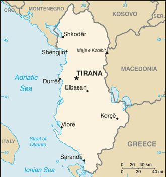
Map image could not be loaded. Open source image.
ⓘ
CIA World Factbook map, February 2021 media edition. Identity reviewed; current boundaries have not been audited. visual contact sheet or original identity check; does not verify current boundaries Boundaries, place names and designations may be dated or disputed; original annotations retained. SHA-256: 968f1d6b488da0bfb1d7cf33d4491bed1ce0e71409a5f57df65cd5097d9e770b. Provenance and inspection record.ⓘ
World Bank directory coordinates; approximate location, not a country center. Coordinate reference date is not supplied by the directory. Natural Earth 1:110m land (2022 source); simplified coastline, no political borders. Map source. Land SVG SHA-256: CF26056A39DC0A5B02F65704E279DFA86E77539A8387D0B2C92F907A67739E5E.Sections in Geography
Geography
Location:2
Southeastern Europe, bordering the Adriatic Sea and Ionian Sea, between Greece to the south and Montenegro and Kosovo to the north
Geographic coordinates:3
41 00 N, 20 00 E
Map references:4
Europe
Area:5
Surface area: 28,750 square kilometers (2024)
Area - comparative:7
slightly smaller than Maryland
Land boundaries:8
Coastline:9
362 km
Maritime claims:10
Climate:11
mild temperate; cool, cloudy, wet winters; hot, clear, dry summers; interior is cooler and wetter
Terrain:12
mostly mountains and hills; small plains along coast
Elevation:13
Natural resources:14
petroleum, natural gas, coal, bauxite, chromite, copper, iron ore, nickel, salt, timber, hydropower, arable land
Land use:15
agricultural land:38.1% (2023 est.)
arable land:21.6% (2023 est.)
permanent crops:3.2% (2023 est.)
permanent pasture:13.4% (2023 est.)
forest:34.3% (2023 est.)
other:27.5% (2023 est.)
Irrigated land:16
Major lakes (area sq km):17
Major watersheds (area sq km):18
Atlantic Ocean drainage:(Black Sea) Danube (795,656 sq km)
Population distribution:19
a fairly even distribution, with somewhat higher concentrations of people in the western and central parts of the country
Natural hazards:20
destructive earthquakes; tsunamis occur along southwestern coast; floods; drought
Geography - note:21
strategic location along Strait of Otranto (links Adriatic Sea to Ionian Sea and Mediterranean Sea)
Notes & sources
- Location. Reference edition; observation: dates as stated in text. Field last updated: not supplied; profile fallback: 2025-12-09 11:53:33 -0500 (not a field revision date); needs review. Reference source. Edition retrieval date: not supplied (retrieval only). ↩
- Geographic coordinates. Reference edition; observation: dates as stated in text. Field last updated: not supplied; profile fallback: 2025-12-09 11:53:33 -0500 (not a field revision date); needs review. Reference source. Edition retrieval date: not supplied (retrieval only). ↩
- Map references. Reference edition; observation: dates as stated in text. Field last updated: not supplied; profile fallback: 2025-12-09 11:53:33 -0500 (not a field revision date); needs review. Reference source. Edition retrieval date: not supplied (retrieval only). ↩
- Area. Reference edition; observation: dates as stated in text. Field last updated: not supplied; profile fallback: 2025-12-09 11:53:33 -0500 (not a field revision date); needs review. Reference source. The archived total area has no reference year and territorial coverage may differ from World Bank surface area. World Bank: 28,750 square kilometers (2024). Reference: 28,748 square kilometers. Edition retrieval date: not supplied (retrieval only). ↩
- Surface area. Surface area: observation 2024; checked 2026-10-29; single source. World Bank World Development Indicators. The archived total area has no reference year and territorial coverage may differ from World Bank surface area. World Bank: 28,750 square kilometers (2024). Reference: 28,748 square kilometers. ↩
- Area - comparative. Reference edition; observation: dates as stated in text. Field last updated: not supplied; profile fallback: 2025-12-09 11:53:33 -0500 (not a field revision date); needs review. Reference source. Edition retrieval date: not supplied (retrieval only). ↩
- Land boundaries. Reference edition; observation: dates as stated in text. Field last updated: not supplied; profile fallback: 2025-12-09 11:53:33 -0500 (not a field revision date); needs review. Reference source. Edition retrieval date: not supplied (retrieval only). ↩
- Coastline. Reference edition; observation: dates as stated in text. Field last updated: not supplied; profile fallback: 2025-12-09 11:53:33 -0500 (not a field revision date); needs review. Reference source. Edition retrieval date: not supplied (retrieval only). ↩
- Maritime claims. Reference edition; observation: dates as stated in text. Field last updated: not supplied; profile fallback: 2025-12-09 11:53:33 -0500 (not a field revision date); needs review. Reference source. Edition retrieval date: not supplied (retrieval only). ↩
- Climate. Reference edition; observation: dates as stated in text. Field last updated: not supplied; profile fallback: 2025-12-09 11:53:33 -0500 (not a field revision date); needs review. Reference source. Edition retrieval date: not supplied (retrieval only). ↩
- Terrain. Reference edition; observation: dates as stated in text. Field last updated: not supplied; profile fallback: 2025-12-09 11:53:33 -0500 (not a field revision date); needs review. Reference source. Edition retrieval date: not supplied (retrieval only). ↩
- Elevation. Reference edition; observation: dates as stated in text. Field last updated: not supplied; profile fallback: 2025-12-09 11:53:33 -0500 (not a field revision date); needs review. Reference source. Edition retrieval date: not supplied (retrieval only). ↩
- Natural resources. Reference edition; observation: dates as stated in text. Field last updated: not supplied; profile fallback: 2025-12-09 11:53:33 -0500 (not a field revision date); needs review. Reference source. Edition retrieval date: not supplied (retrieval only). ↩
- Land use. Reference edition; observation: dates as stated in text. Field last updated: not supplied; profile fallback: 2025-12-09 11:53:33 -0500 (not a field revision date); needs review. Reference source. Edition retrieval date: not supplied (retrieval only). ↩
- Irrigated land. Reference edition; observation: 2022. Field last updated: not supplied; profile fallback: 2025-12-09 11:53:33 -0500 (not a field revision date); needs review. Reference source. Edition retrieval date: not supplied (retrieval only). ↩
- Major lakes (area sq km). Reference edition; observation: dates as stated in text. Field last updated: not supplied; profile fallback: 2025-12-09 11:53:33 -0500 (not a field revision date); needs review. Reference source. Edition retrieval date: not supplied (retrieval only). ↩
- Major watersheds (area sq km). Reference edition; observation: dates as stated in text. Field last updated: not supplied; profile fallback: 2025-12-09 11:53:33 -0500 (not a field revision date); needs review. Reference source. Edition retrieval date: not supplied (retrieval only). ↩
- Population distribution. Reference edition; observation: dates as stated in text. Field last updated: not supplied; profile fallback: 2025-12-09 11:53:33 -0500 (not a field revision date); needs review. Reference source. Edition retrieval date: not supplied (retrieval only). ↩
- Natural hazards. Reference edition; observation: dates as stated in text. Field last updated: not supplied; profile fallback: 2025-12-09 11:53:33 -0500 (not a field revision date); needs review. Reference source. Edition retrieval date: not supplied (retrieval only). ↩
- Geography - note. Reference edition; observation: dates as stated in text. Field last updated: not supplied; profile fallback: 2025-12-09 11:53:33 -0500 (not a field revision date); needs review. Reference source. Edition retrieval date: not supplied (retrieval only). ↩